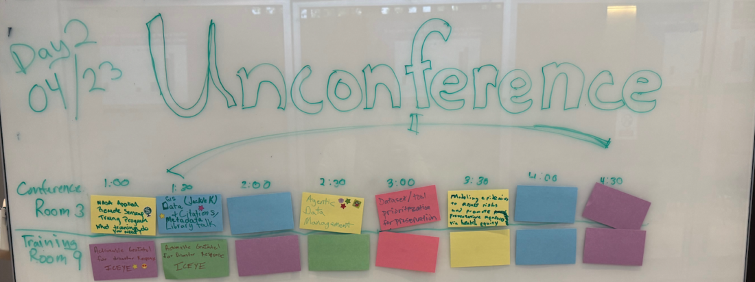
Summaries of selected talks from FedGeoDay 2026, Day 1, April 2026, US Census Bureau, Suitland, MD Once again, I served on the FedGeoDay organizing committee this year. FedGeoDay continues to be one of the higher-value events on my calendar, and this year was no exception. With a focus on data preservation and federal data stewardship, … Continue reading FedGeoDay 2026: Four Talks Worth Your Attention
Tag: Data
Sovereignty and Open Source
Open source geospatial tools are good. I have been making some form of that argument for most of my career, especially on this blog. The mature projects are equal to or better than their proprietary alternatives. The communities that build and maintain them represent some of the best technical talent working in this space. None … Continue reading Sovereignty and Open Source
The Siren Song of Global Identifiers
[Author's Note: At the time of this writing, I am a member of the OSM US Advisory Council. This post reflects my personal analysis and opinion. It has not been endorsed by OSM US, and is not intended to reflect their views.] Recently, a proposal submitted to the Open Geospatial Consortium (OGC) set off a … Continue reading The Siren Song of Global Identifiers
Data Preservation: Let the Pain Guide You
As I’ve recounted before, what became HIFLD started as the M: drive on a Windows server in a musty government building in Norfolk, VA. Early exercises made it obvious that the data on our M: drive didn’t match the data on other M: drives. They also made it clear that sharing data, especially across 2002-vintage … Continue reading Data Preservation: Let the Pain Guide You
Data Over Software
One of the first tasks I ever had in my then-new GIS career was doing AML development in ARC/INFO 6.x for a data production project. My code parsed DXF exported from AutoCAD R11 for DOS and then assigned attributes based on things like layer, color, line weight, feature type, and others. It also georeferenced the … Continue reading Data Over Software


