Where It Diverges From, and Could Complement, Embedding Fields and Agentic Orchestration
Geospatial analysis has long relied on symbolic representations and formal operations. A geographic information system stores typed geometries, associates them with coordinate reference systems, computes topological predicates, and executes workflows with defined inputs and outputs. The GIS analyst’s expertise consists, in part, of knowing how and when specific operations compose for a given task. For example, when a buffer must precede an intersection, when a spatial join requires aggregation, and why a planar distance computed directly on longitude and latitude is not a distance in meters. Much of this knowledge is explicit, rule-governed, and checkable.
The approaches examined here place important decisions about representation and workflow design in learned components. Embedding field models summarize the Earth’s surface as vectors that support similarity search and few-label classification without any explicit representation of what the vectors mean (Brown et al., 2025). Agentic systems place a large language model in charge of planning: it reads a natural-language question, decomposes it into steps, and calls geoprocessing tools, foundation models, and data services to execute them (Bell et al., 2026; Slonim et al., 2026). The symbolic machinery of GIS remains available for computation, but these architectures do not, by themselves, make it responsible for validating the workflow or its accepted result.
Neuro-symbolic AI asks whether leaving these decisions to learned components sacrifices opportunities to check the workflow and its results, and whether those checks can be added while retaining the capabilities of the neural components. The field’s premise is that neural networks excel at perception and pattern completion while symbolic systems excel at compositional reasoning, constraint satisfaction, and explanation, and that connecting neural learning with explicit knowledge representations and logical reasoning can give a system both capabilities (Garcez & Lamb, 2023). The question I want to explore is narrower: for geospatial workloads specifically, where does a neuro-symbolic architecture differ from the embedding-field and agentic approaches now being built by LGND, Google, and others, and where would it complement them?
Neuro-Symbolic AI as a Set of Integration Patterns
The term covers a family of architectures rather than a single method. Kautz’s taxonomy, introduced in his 2020 Robert S. Engelmore Memorial Lecture and subsequently used in surveys, distinguishes six patterns by how neural and symbolic components relate (Kautz, 2022; Lamb et al., 2020; Wan et al., 2024). Four are relevant here.
In a Neuro | Symbolic pipeline, a neural network transforms non-symbolic input such as imagery into a symbolic representation, and a symbolic reasoner operates on the result. The neuro-symbolic concept learner and DeepProbLog are the canonical examples (Lamb et al., 2020). In Symbolic[Neuro], a symbolic problem solver owns the control flow and invokes neural subroutines for pattern recognition; AlphaGo’s Monte Carlo tree search calling a neural value network is the usual illustration (Wan et al., 2024). In Neuro: Symbolic → Neuro, symbolic rules are compiled into the structure or training of the network itself, as in logical neural networks that embed fuzzy logic in the architecture. In Neuro[Symbolic], a neural system owns control and invokes a symbolic reasoner when it judges one is needed, a pattern Kautz associated with Kahneman’s fast and slow thinking and regarded as the most promising (Lamb et al., 2020).
When tool use becomes symbolic reasoning
Kautz’s categories describe the shape of an architecture; they do not by themselves settle whether a given system performs symbolic reasoning. A language model that calls a PostGIS function has the shape of Neuro[Symbolic], a neural controller invoking a symbolic component, and yet the component it invokes computes a predicate rather than reasoning about the workflow. Retrieval augmentation, chain-of-thought prompting, and function calling raise a related question: none, by itself, establishes that a symbolic component performs logical inference over the workflow. Garcez and Lamb (2023) describe neuro-symbolic AI as integrating learning with explicit knowledge representation and logical reasoning. I use that understanding here.
For the verification architectures discussed here, I use a two-part criterion. It is a working definition for this argument, rather than a definition of the entire field. A system is treated as neuro-symbolic for present purposes when (a) a symbolic component uses explicit rules to determine whether operations can be combined as proposed or whether assertions are mutually consistent, rather than only executing individual operations, and (b) the outcome of that inference either constrains what the neural component may do next, by rejecting a plan, flagging a classification, or narrowing the admissible actions, or determines the accepted result. The second part alone is insufficient; a hard-coded guardrail that vetoes certain tool calls constrains the neural component without reasoning. The first part alone is insufficient; a reasoner whose verdict is reported but never acted on is an explanation facility, not an integration. Both parts together describe what recent verification-guided systems do: they autoformalize a model’s claims into first-order logic, check them with an SMT solver, and feed the solver’s verdict back as a correction the model must address (Singh et al., 2026). VERUS-LM carries the division further, restricting the language model to extracting values and constraints from the problem statement and delegating inference to an IDP-Z3 solver whose output is the answer (Callewaert et al., 2026).
Under this criterion, the agentic geospatial systems discussed below are tool-augmented rather than neuro-symbolic, even though they have Neuro[Symbolic] shape. The distinction concerns whether symbolic inference governs the workflow or its accepted result.
Garcez and Lamb (2023) identify the recurring motivations for integration as trust, safety, interpretability, and accountability. These motivations are relevant to geospatial applications in insurance, defense, and environmental compliance, where analysts must be able to justify consequential results.
What Makes the Geospatial Workload Different
Rolf et al. (2024) argue that satellite data constitutes a distinct modality for machine learning, with characteristics that methods designed for natural images and text handle poorly: labels collected independently of the imagery they are paired with, variable spectral channels across sensors, strong spatial and temporal autocorrelation, and deployment conditions that shift across geographies. The argument extends beyond satellite data to the geospatial workload as a whole, and three features of that workload bear directly on the neuro-symbolic question.
First, many spatial relations can be defined explicitly and checked using logical rules. RCC8, within the Region Connection Calculus, defines eight jointly exhaustive and pairwise disjoint topological relations between regions. Its composition table constrains the possible relations between two regions from their relations to a third; it need not identify a unique relation (Randell et al., 1992). GeoSPARQL supports the RCC8 relation family, allowing queries to express containment, overlap, and adjacency as explicit predicates (Open Geospatial Consortium, 2024). Metric and geometric operations also have defined semantics, conditional on the geometry, coordinate reference system, algorithm, and numerical precision. This formal structure supports checking a representation of the world; it does not guarantee that the representation is accurate.
Second, geospatial datasets often already describe identifiable features and explicit relationships among them. Administrative units can form declared hierarchies; census blocks nest within tracts; road segments connect at nodes; a hazard footprint intersects a set of structures. KnowWhereGraph integrates more than thirty data layers at the interface of human and environmental systems into a graph reported to contain over twenty-eight billion triples, with a schema designed around geospatial integration and geo-enrichment services (Janowicz et al., 2022; Shimizu et al., 2025). A geospatial knowledge graph can make relationships already present in the data explicit and available for reasoning.
Third, errors can be consequential and detectable. A land-cover classification that conflicts with a reference water-body layer can be flagged for review, although the conflict alone does not establish which source is wrong. A workflow that reports planar areas computed on unprojected longitude and latitude as square meters has a detectable unit error. The benchmarks discussed below identify related problems with geometry, coordinate systems, units, and workflow composition.
The distinction between hard constraints and defeasible expectations matters here. Hard constraints are statements about the data model and the declared ontology: a polygon must be valid under the Simple Features rules, a measurement must use a CRS or geodesic method appropriate to its declared accuracy and geographic extent, a pixel cannot carry two mutually exclusive land-cover classes, a tract must be contained by the county it is recorded as belonging to, a quantity labeled in meters cannot be an unconverted planar measurement in degrees. A violation is an error in the analysis or in the data, and either way it must be resolved before the result is used. Defeasible expectations are statements about the world: built-up land is unlikely inside a protected area, cropland is unlikely inside a dense urban block, a road segment is unlikely to cross open water. A violation may indicate a misclassification or a genuine anomaly, including the discovery the analysis exists to make. Unauthorized development inside a reserve, a working urban farm, and a causeway are all real. A symbolic layer that treats expectations as constraints will suppress the findings that matter most; one that treats them as triggers for review will route them to a human or to a higher-cost check. Much of the design work lies in deciding which relations express requirements that must be satisfied and which express expectations whose exceptions warrant review.
Language models bring a specific liability to this workload. Manvi et al. (2024) show that LLMs make accurate zero-shot geospatial predictions on objective quantities while exhibiting systematic bias against locations with lower socioeconomic conditions on subjective ones; Gurnee and Tegmark (2024) show that models encode coordinate-like representations of place. Geographic knowledge does not by itself ensure reliable spatial computation. MultiGlobeQA, a 2026 benchmark of 46,060 questions with execution-based ground truth over three knowledge graphs, finds that models handle topological relations and directions comparatively well and collapse on tasks requiring grid indexing and shape computation; performance plateaus below two-thirds even when the ground-truth information is supplied, which its authors read as a bottleneck in computation rather than in knowledge access (Böckling et al., 2026). These results motivate testing whether explicit spatial computation can improve performance beyond retrieval alone.
The Current Frontier
Embedding fields: AlphaEarth Foundations, Clay, LGND, and TESSERA
AlphaEarth Foundations is an embedding field model that assimilates optical, radar, lidar, and climate observations into a representation of the Earth’s land surface, with annual layers of 64-dimensional vectors at 10-meter resolution (Brown et al., 2025). As accessed on October 16, 2026, the Earth Engine catalog lists complete annual coverage for 2017–2024 (Google & Google DeepMind, n.d.). The design goal is accurate mapping from sparse labels: because the embeddings already encode surface and environmental properties, a downstream task needs far fewer labeled examples than training a bespoke model would require. A case study published by Google Earth seeded a search for palm-oil mill effluent lagoons across Sumatra with fifty labels and recovered most of the known mills in two training iterations (Wilkins, 2026). Independent applications have followed, including urban air-quality prediction (Alvarez et al., 2025). Rahman (2026) probes the representation directly and finds that individual embedding dimensions map onto physical land-surface variables, with models using the full embedding space reconstructing temperature and elevation at R² near 0.97 in the study’s evaluation; the same paper then builds a retrieval-augmented system that answers natural-language environmental queries over a FAISS index of twelve million vectors.
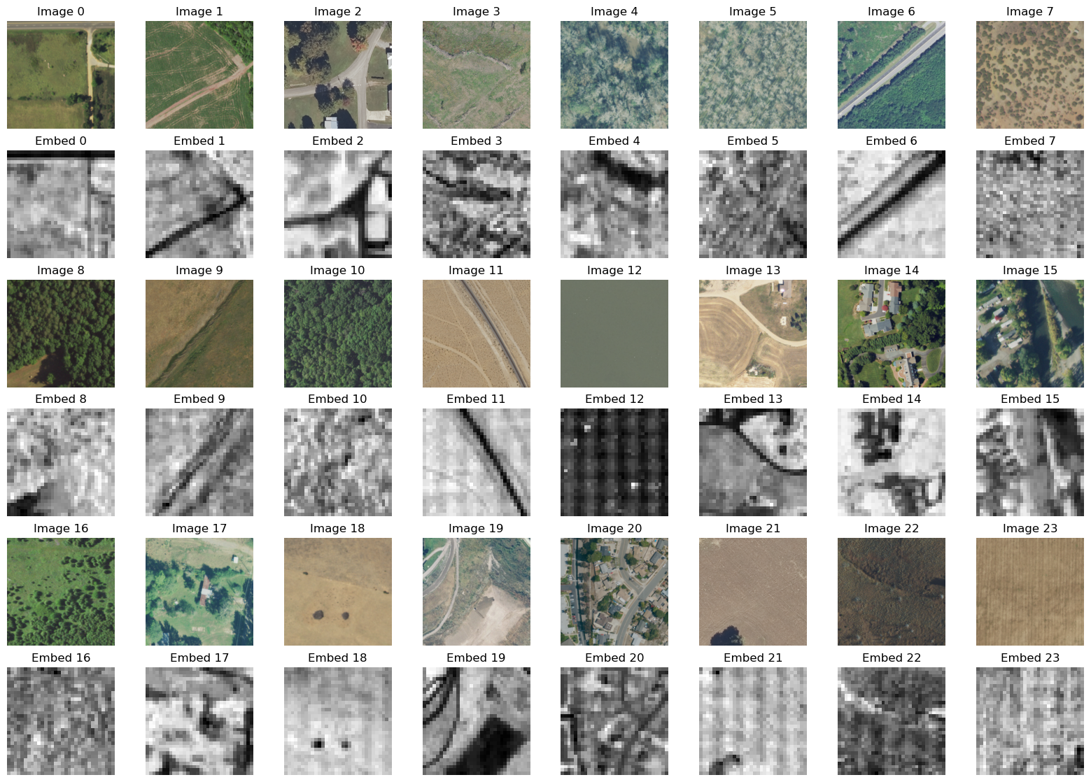
Clay occupies the same architectural niche in the open-source world. It is a masked-autoencoder vision transformer trained on Sentinel-1, Sentinel-2, Landsat, NAIP, and other sources, released under Apache-2.0 with open training data, and designed to be used in three ways: generating embeddings for any location and time, fine-tuning for downstream tasks, and serving as a backbone (Clay Foundation, 2024; Development Seed, n.d.). TESSERA, from a Cambridge-led group, is a third entrant: pixel-wise 128-dimensional annual embeddings from Sentinel-1 and Sentinel-2 time series, trained with Barlow Twins to preserve the temporal signal that compositing discards, released with open weights and a Python library, and reported to match or exceed AlphaEarth on several downstream tasks (Feng et al., 2026). AlphaEarth and TESSERA provide global annual embedding layers; Clay supplies a reusable model for generating embeddings from supported inputs. Their shared emphasis on reusable representations supports amortizing computation across downstream tasks, although their released products differ.
Clay’s builders founded LGND in 2024 (LGND, n.d.). At the company’s seed announcement, co-founder Dan Hammer described geographic embeddings as a foundational data object for geospatial information, comparable to the role map tiles played in web mapping (LGND, 2025). The platform creates embeddings with geo-foundation models including Clay, runs similarity search against a global embedding database, and fetches source imagery. Union.ai’s case study describes a training workload that maps geo-embeddings into a text-embedding space to support natural-language search over satellite imagery (Union.ai, n.d.). LGND’s current site lists Studio as its web application and Geo as its MCP tools, consistent with its stated direction of serving both analysts and AI systems (LGND, n.d.).
The economic strength of this architecture is reuse: representation learning and embedding generation can be amortized across tasks. LGND describes this as front-loading shared computation (LGND, 2025). Retrieval, adaptation, validation, storage, and updates still incur costs. The limitation is equally structural. An embedding encodes what a place looks like across many observations; it does not explicitly declare the place’s identity, its relations to other objects, or the rules it must satisfy. Similarity in embedding space is evidence for class membership, not a determination of it, and a nearest-neighbor search returns candidates rather than facts. The Sumatra case study is explicit that the output of the embedding search was a few thousand locations for a human to review (Wilkins, 2026). Rahman’s results suggest that some embedding dimensions can be associated with physical variables, which motivates testing whether a symbolic layer could use those associations. The embedding itself, however, does not identify which physical variable a dimension represents.
Agentic orchestration: Google’s Geospatial Reasoning agent and autonomous GIS
Google introduced Geospatial Reasoning in April 2025 as a research effort pairing Gemini with new remote-sensing foundation models and with tools for Earth Engine, BigQuery, and the Maps Platform, so that a natural-language question could be decomposed into a planned chain of data retrieval, model inference, and synthesis (Schottlander & Shekel, 2025). The Earth AI technical report formalized the design as three families of foundation models, imagery, population, and environment, orchestrated by a Gemini-powered agent, and reported that on a question-answering benchmark the agent scored 0.82 against 0.50 for a baseline Gemini 2.5 Pro configuration, with the largest gains on analytical and relational questions (Bell et al., 2026).
The October 2026 report on the expanded Geospatial Reasoning agent describes an architecture that organizes capabilities into modular domain skills and adds an upfront planning stage that decomposes a query into a multi-stage workflow before execution (Slonim et al., 2026). It introduces two benchmarks. GeoKTools consists of templated queries with deterministic reference solvers that vary the number of tool types required. GeoExpertQueries consists of open-ended problems drawn from practitioner use cases, each paired with a consensus golden workflow derived from three independent expert workflows and scored by a human-validated, tool-agnostic autorater. The report compares four configurations across two Gemini models: a standalone LLM, the LLM with basic tools, the LLM with the agent’s skills but without upfront planning, and the full agent. The reported pattern is that an advanced model with basic tools recovers much of the answer on templated queries but satisfies only a small fraction of expert workflows on open-ended problems, while the full agent performs well on both. On a 0–100 scale, the report’s Table 4 gives mean GeoExpertQueries scores across three runs for Gemini 3.8 Flash as 0.0 standalone, 3.3 with basic tools, 52.2 with skills but no planning, and 62.7 for the full agent (Slonim et al., 2026). Most of the gain comes from the domain skills and tools; the combined planning and execution guidance adds 10.5 points for Flash and, for Gemini 3.1 Pro, lowers the score from 50.8 to 47.6, a difference the report discusses explicitly (Slonim et al., 2026). Neither configuration measures symbolic verification, and the Pro result is a caution against reading “planning is the bottleneck” as “any added planning stage will help.”
The GeoExpertQueries autorater compares the agent’s trace against the golden workflow’s steps. By the report’s own description, it does not penalize reasonable choices for parameters the query leaves open, skipped optional steps, missing maps or charts, a failed tool call recovered by an equivalent alternative, or technical details such as projections, normalization, units, or resolution (Slonim et al., 2026). Google’s announcement states the consequence directly: the scores reflect whether the analysis took the right steps, not whether the final answer is correct, and the agent’s output is accordingly treated as a first draft for experts to review (Shetty & Barrington, 2026). The benchmark measures workflow quality while excluding technical correctness properties that an appropriately specified symbolic checker could assess.
The academic line toward autonomous GIS predates and parallels this work. Li and Ning (2023) proposed LLM-Geo, which decomposes a spatial question into a directed acyclic graph of geoprocessing steps, generates code for each, and self-debugs on failure; a sixteen-author research agenda has since defined five levels of GIS autonomy and demonstrated proof-of-concept agents for data retrieval, analysis, and cartography (Li et al., 2025). The benchmarks built to evaluate this line provide evidence about where such systems fail. GeoAnalystBench, fifty expert-validated Python tasks, found that proprietary models produce valid workflows at high rates while tasks requiring spatial relationship detection or optimal site selection remain hardest for every model tested (Zhang et al., 2025). GeoAgentBench introduced dynamic execution with runtime feedback and multimodal evaluation of map outputs, finding that the Plan-and-React architecture outperforms alternatives on multi-step reasoning and error recovery (Yu et al., 2026). GISAgentBench, 349 practitioner-sourced tasks instantiated on real public data with exact ground-truth output files, is the only one of these with deterministic, tolerance-aware output scoring rather than code similarity or model judging. The best of six agents completed 32.7% of tasks under strict scoring. Failures concentrated in workflow planning: omitted or mis-ordered operations, selection of the wrong tool, and loops that repeated or undid steps without converging. One example was a plain spatial join where an aggregating join was needed. Parameter or formula errors appeared in 7.8% of the 1,381 wrong-but-attempted runs analyzed; the failure categories could overlap (Pothuri et al., 2026).
Placing the frontier on the taxonomy
Embedding fields are neural. The symbolic machinery that surrounds them, Earth Engine’s raster algebra, a vector database’s index, the GIS that consumes a classified map, operates on their outputs but does not participate in producing the representation. AlphaEarth, Clay, and TESSERA supply neural representations that could serve as perception components in an integrated architecture.
Agentic orchestration has Neuro[Symbolic] shape: the LLM controls the workflow and invokes geoprocessing tools, foundation models, and data services. Under the working definition used here, these systems remain tool-augmented because their published descriptions do not identify a symbolic verifier that can reject a plan. Google’s modular skills organize domain capabilities into reusable components, while its planning stage makes the proposed sequence of operations explicit. The reported gains from skills and the mixed results from added planning show that workflow design affects performance. Whether symbolic verification would improve that performance remains untested.
The embedding-field camp has addressed perception at scale and left reasoning to downstream users. The agentic camp has attacked reasoning with a neural planner and exposed substantial errors in workflow composition. The reports examined here do not describe an integrated symbolic verifier that can reject a plan or flag a classification by reasoning over declared constraints before the result is accepted.
Where symbolic reasoning could help
Representation inference and control
Representation. An embedding field represents a location as a point in a learned vector space. A geospatial knowledge graph represents it as a node with typed relations to other nodes: contained in a jurisdiction, adjacent to a parcel, crossed by a road, affected by a hazard event (Janowicz et al., 2022). Mai et al. (2022) describe the two as the subsymbolic and symbolic traditions of GeoAI, and note that knowledge-graph embedding methods designed for general graphs make poor use of spatial and temporal structure. A neuro-symbolic system would hold both: the embedding as evidence about what the place looks like, the graph as the record of what it is and how it relates. Potnis et al. (2023) proposed a related integration for remote-sensing scene understanding, infusing knowledge-graph embeddings of spatio-contextual relations into a deep network pipeline for land-cover classification, object detection, and instance segmentation.
Inference. Embedding similarity and LLM generation are statistical. RCC8 reasoning and constraint satisfaction operate over explicit relations and rules; buffer-and-intersect operations compute geometry under declared semantics. Current agentic systems obtain the deterministic computation by calling tools, which is correct as far as it goes; the gap is that the choice of which computation to run, in what order, over which inputs, is generated by the model without the explicit verification proposed here. The verification-guided frameworks discussed earlier address this for logical claims; geoprocessing workflows specify geometry types, coordinate reference systems, measurement units, and conditions that operations require. These provide information that a verifier could use to check a proposed workflow against explicit rules.
Control. In the agentic systems, a neural planner selects the operations and their sequence, and symbolic tools execute the individual operations. The alternative pattern, Symbolic[Neuro], inverts this: a symbolic planner uses explicit rules about each operation’s inputs, outputs, and preconditions to determine how operations can be combined, and neural components are invoked where perception is required, classifying a scene, detecting a change, ranking candidates by similarity. GIS has had declarative workflow systems for decades; the ModelBuilder-style DAG that LLM-Geo generates is one. Language models now provide a practical way to translate a broad range of natural-language questions into a first draft of such a DAG. The design question is whether the model’s draft must pass verification before execution.
Four integration points
Grounding embeddings into typed objects. An embedding search returns candidates; many downstream analyses require typed objects. The step between, thresholding, clustering, vectorizing, assigning a class with a confidence, and committing the result to a typed geometry in a known CRS, is where a Neuro | Symbolic pipeline would begin. Once a palm-oil mill lagoon is a polygon with a class label and a provenance record pointing back to the embedding query and the labels that seeded it, subsequent operations can be checked against declared types, relations, and constraints. LGND’s translation of geo-embeddings into a text-embedding space already supports the retrieval half of this; the grounding step would turn retrieved candidates into classified geographic features with explicit geometry types, coordinate reference systems, confidence estimates, and provenance. A symbolic component could then check those features against declared spatial relations and rules. Rahman’s finding that AlphaEarth dimensions correspond to physical variables motivates testing interpretable grounding rules; predictive correlations alone do not establish reliable thresholds (Rahman, 2026).
Constraining perception with the knowledge graph. A geospatial knowledge graph can supply contextual relations against which a classifier’s outputs can be checked. Each relation must be identified as a hard constraint or an expectation, using the distinction established earlier. A hard-constraint violation requires resolution before the result is used, although the error may lie in the classification or the reference data. An expectation triggers review, a higher-resolution check, or a query against a permit or infrastructure record. The completeness of the reference data matters: a building footprint outside every parcel violates a hard constraint only if the parcel layer is complete and an applicable containment rule has been established. Otherwise, the discrepancy warrants investigation. Potnis et al. (2023) proposed incorporating spatial contextual relations during model training. Checking outputs against those relations would allow the checks to be implemented separately from training, with their treatment recorded explicitly in the knowledge graph. KnowWhereGraph’s geo-enrichment services offer a starting point for retrieving relevant relations (Janowicz et al., 2022).
Verifying the plan before execution. GISAgentBench’s failure analysis suggests targets for a verifier: omitted operations, mis-ordered operations, wrong-tool substitution, and non-converging loops (Pothuri et al., 2026), but these failures are not equally detectable from the plan alone. The proposal distinguishes three tiers of checking.
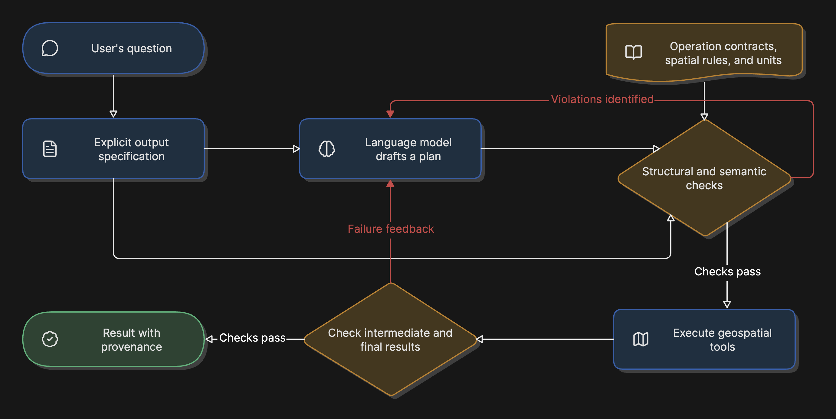
Structural validation examines the plan as a typed graph of operations. For each supported geoprocessing operation, a verifier needs a machine-readable description of its accepted input geometry types, output geometry type, CRS requirements, parameter units, and output fields. The checks this supports are conditional on the function variant, because the same operation name carries different semantics across implementations. PostGIS’s ST_Buffer interprets distance differently depending on the input type. For a geometry, the distance uses the coordinate reference system’s units, which are degrees for unprojected longitude and latitude. For a geography, the distance is in meters. The geography variant selects a suitable planar reference system, computes the buffer there, and transforms the result back to WGS 84. This differs from PostGIS’s geography length and area functions, which use geodesic measurements (PostGIS Project, n.d.-a, n.d.-b, n.d.-c). A structural checker therefore inspects the function variant, the operand’s data type and CRS, the argument’s declared unit, and the measurement the plan intends, and flags combinations that cannot produce the intended measurement. Examples include a planar buffer with a unitless argument on unprojected coordinates where the question asked for a distance in kilometers, and a planar length on the same coordinates feeding a column labeled meters. A step that references a layer that is neither a declared external input nor the output of a prior step has a dangling edge. A join whose output schema lacks a column a downstream step consumes is a type mismatch. What structural checks do not establish on their own is cardinality: that an output has one row per school is a property of the data, not of the column types, and a checker can enforce it only once the requirement has been encoded, which is the job of the next tier. Structural checks need no execution; they need formalized, implementation-specific signatures and a declaration of the intended measurement units. Library documentation supplies much of the underlying information, but converting it into complete machine-checkable contracts is additional engineering work.
Semantic validation examines whether the plan, if executed correctly, would answer the question asked. Omitting a required clip or aggregation is a semantic failure. Detecting it requires a formal statement of the intended result: what the output should contain, keyed by what, in what units, over what extent. A plan can be type-correct and answer the wrong question. GISAgentBench provides output contracts and reference trajectories; GeoExpertQueries provides golden workflows. These allow evaluation against an explicit reference. A live user query must instead be translated into a specification, and that translation can itself be wrong. The first job of a semantic verifier is therefore to make the agent commit to an explicit output specification before planning, so that the plan can be checked against it. This is analogous to the formalization step in verification-guided reasoning frameworks, which translate claims into logic before checking them (Singh et al., 2026), and it is where most of the engineering difficulty lies.
Execution-dependent checks examine properties not established by the declared plan alone: unexpectedly empty intersections, zero denominators, unexpected output counts, and loops that fail to converge within a declared limit. Assertions on intermediate results and runtime feedback can help detect these problems; GeoAgentBench demonstrates the value of runtime feedback for recovery (Yu et al., 2026). Data completeness is a separate limit: execution may reveal gaps, but establishing completeness generally requires coverage metadata or an independent reference.
The LLM-Geo school-walkability demonstration in the autonomous-GIS research agenda provides a task for illustrating these boundaries. It asks for a walkability score for each school, defined as the ratio of sidewalk length to road length within a one-kilometer buffer, followed by a map per school, and reports correct results, sometimes after a second attempt with autonomous debugging (Li et al., 2025). The following flawed plan is an illustrative reconstruction, not a reported failure from that demonstration. It uses the GISAgentBench failure classes to show which checks would apply and assumes, for illustration, that the input layers arrive in WGS 84.
Suppose an agent plans: load schools, sidewalks, and roads; buffer schools by 1; intersect sidewalks with buffers; intersect roads with buffers; compute lengths; join; divide; map. Structural validation, given the declared intent of a one-kilometer radius and lengths in meters, catches two things without executing anything. The buffer is a planar geometry operation with a unitless argument on unprojected coordinates, so “1” is one degree, and the checker demands either an appropriate projected CRS with a converted distance or the meter-based geography variant with a distance of 1,000. The lengths, computed by the planar function on the same coordinates, would be in degrees while feeding a column the plan labels in meters. Semantic validation requires that an output specification, one row per school, a dimensionless ratio, numerator and denominator both clipped to the same buffer, was extracted before planning. Given that specification, two further flaws become visible: the join of per-segment sidewalk lengths to per-segment road lengths yields one row per segment pair rather than one per school unless an aggregation by school is inserted, and if the plan clipped sidewalks to the buffer but not roads, the omitted clip is a missing operation on the path to “road length within the buffer.” A checker cannot establish either violation from types alone; it needs a declared requirement or another source of task semantics. Execution-dependent checks address whether any buffer contains no roads and whether the per-school map renders. Assessing sidewalk coverage additionally requires metadata or an independent reference. In this reconstruction, structural checks catch the errors that produce confidently wrong numbers; semantic checks catch the errors that produce the wrong analysis, provided the specification exists; and nothing in the plan reveals whether the data is fit for purpose.
The walkability example identifies errors that structural and semantic checks could detect, provided the necessary operation descriptions and output specifications exist. GISAgentBench’s output contracts and reference trajectories offer starting material, but extracting and validating specifications from live user requests remains a separate challenge. The share of the best agent’s 67.3% unsuccessful tasks attributable to detectable errors has not been measured. Testing a verifier would establish whether it improves task success and how often it rejects a valid plan.
Carrying provenance to the result. Consequential geospatial decisions benefit from a record of how a result was derived. A neuro-symbolic pipeline can record the embedding query, the grounding threshold, the graph relations and their constraint or expectation labels, the checked plan, and the operations producing the result. Such a record must be designed into the system and must identify versions of the data layers, rule sets, and model checkpoints. The agentic systems produce a narrative of their reasoning; the knowledge-graph systems produce a query trace. Combining them in a maintained record yields an audit trail that is both human-readable and machine-checkable and can support model review and external scrutiny. Provenance does not prevent a biased decision; it helps a reviewer investigate potential sources of bias. Manvi et al.’s (2024) finding that LLM geospatial priors vary systematically with socioeconomic condition is the case in point: a provenance record that shows an estimate came from the model’s learned associations, rather than a calculation using identified observations and explicit rules, tells a reviewer what to investigate. Observed data and declared rules carry their own omissions and assumptions. Traceability helps reviewers identify where those may affect a result, but assessing their significance still requires judgment.
The proposed architecture would retain embedding models for perception and language models for drafting workflows from open-ended questions. Embeddings would continue to support reuse across tasks and adaptation from limited labels. Symbolic components would check classifications and proposed workflows against explicit rules, with the authority to require revision before a result is accepted.
Constraints
Knowledge engineering is expensive and the knowledge goes stale. KnowWhereGraph took a multi-institution NSF project to build and describes itself as continuously growing (Janowicz et al., 2022). A verifier for geoprocessing plans needs a formal description of every operation an agent might call, maintained as tool libraries evolve, plus explicit labeling of constraints and expectations for every relation the knowledge layer enforces. The initial signature work can be bounded by restricting the supported tool set. Deciding which relations are constraints and which are expectations requires judgment that varies by application and region. The system’s designers must also specify who is responsible for reviewing and updating those decisions.
Qualitative spatial reasoning has tractability limits. Deciding consistency of general RCC8 constraint networks is NP-complete, although tractable subsets exist (Renz & Nebel, 1999). A system that reasons over every parcel in a county must choose which relations to materialize and which to compute on demand. These choices shape both practical performance and the guarantees the system can provide.
The benchmarks discussed here evaluate agentic systems. They provide a selective view of that work, rather than an exhaustive account of neuro-symbolic geospatial research. The 2025–2026 benchmarks reviewed above measure agentic systems and are well-suited to measuring whether a plan verifier reduces the failure classes they identify; GISAgentBench, with its exact ground-truth outputs, is the natural testbed for the structural tier. None measures whether a knowledge-graph constraint improves embedding-derived classification without suppressing true anomalies, or whether a provenance chain is sufficient for a regulatory review. The semantic tier also requires evaluating specification extraction. GISAgentBench includes output contracts, while GeoExpertQueries supplies expert workflows; these are starting points for a dedicated evaluation of whether an agent faithfully formalizes a user’s intended result. They do not by themselves establish the reliability of that extraction step.
Embedding opacity is partial, not total. Rahman’s results motivate testing interpretable grounding rules for AlphaEarth, but that is one model, one region, and one set of target variables. Those results do not establish that the same interpretation transfers to Clay or TESSERA. A grounding layer that depends on interpretable dimensions is brittle to model updates that reshuffle them.
Interoperability between the symbolic and neural components is unstandardized. LGND serves embeddings through its own API; Google exposes its agent through Ask Google Earth and an agent-to-agent service (Shetty & Barrington, 2026); KnowWhereGraph speaks SPARQL; PostGIS speaks SQL. The sources reviewed here do not describe a shared contract for a verifier to read a plan, check it against an external rule set, and return enforceable corrections across these systems. Communication protocols alone do not supply the operation semantics and rejection rules that such integration requires.
The next experiment
The embedding-field and agentic architectures address complementary parts of the geospatial problem. AlphaEarth Foundations, Clay, TESSERA, and LGND’s platform support reuse of learned representations across downstream tasks. Google’s Geospatial Reasoning agent and the autonomous-GIS line have shown that a language model can turn an open question into a workflow and, with planning and domain skills, execute it well enough to outperform the model alone by a wide margin on workflow-quality measures. Their published descriptions do not establish the symbolic verification capability proposed here: checking classifications against declared constraints and checking whether the planned operations accept one another’s outputs and satisfy the task’s stated requirements before accepting the result.
The benchmarks identify failures that motivate verification, while GeoExpertQueries excludes several technical correctness properties that a checker could address. GIS already supplies much of the operational semantics, and language models can expose candidate workflows explicitly. The next step is to select a limited set of geoprocessing operations, encode their input requirements and output properties as machine-checkable rules, and test a verifier against tasks such as those in GISAgentBench. Its effect on task success, false rejections, runtime, and human review effort remains an empirical question.
References
Alvarez, C. I., Ulloa Vaca, C. A., & Echeverria Llumipanta, N. A. (2025). Machine learning for urban air quality prediction using Google AlphaEarth Foundations satellite embeddings: A case study of Quito, Ecuador. Remote Sensing, 17(20), Article 3472. https://doi.org/10.3390/rs17203472
Bell, A., Aides, A., Helmy, A., Muslim, A., Barzilai, A., Slobodkin, A., Jaber, B., Schottlander, D., Leifman, G., Paul, J., Sun, M., Sherman, N., Williams, N., Bjornsson, P., Lee, R., Alcantara, R., Turnbull, T., Shekel, T., Silverman, V., … Shetty, S. (2026). Earth AI: Unlocking geospatial insights with foundation models and cross-modal reasoning (Version 4) [Preprint]. arXiv. https://arxiv.org/abs/2510.18318v4
Böckling, M., Nosova, E., Paulheim, H., & Iana, A. (2026). MultiGlobeQA: A multilingual and globally diverse benchmark for geospatial reasoning [Preprint]. arXiv. https://arxiv.org/abs/2608.03882
Brown, C. F., Kazmierski, M. R., Pasquarella, V. J., Rucklidge, W. J., Samsikova, M., Zhang, C., Shelhamer, E., Lahera, E., Wiles, O., Ilyushchenko, S., Gorelick, N., Zhang, L. L., Alj, S., Schechter, E., Askay, S., Guinan, O., Moore, R., Boukouvalas, A., & Kohli, P. (2025). AlphaEarth Foundations: An embedding field model for accurate and efficient global mapping from sparse label data [Preprint]. arXiv. https://arxiv.org/abs/2507.22291
Callewaert, B., Vandevelde, S., & Vennekens, J. (2026). VERUS-LM: A versatile framework for combining LLMs with symbolic reasoning. Electronic Proceedings in Theoretical Computer Science, 439, 47–62. https://doi.org/10.4204/EPTCS.439.5
Clay Foundation. (2024). Pretrained model release v1.5. https://clay-foundation.github.io/model/release-notes/specification.html
Development Seed. (n.d.). An open foundation model for Earth. https://developmentseed.org/projects/clay/
Feng, Z., Atzberger, C., Jaffer, S., Knezevic, J., Sormunen, S., Young, R., Lisaius, M. C., Immitzer, M., Jackson, T., Ball, J., Coomes, D. A., Madhavapeddy, A., Blake, A., & Keshav, S. (2026). TESSERA: Temporal embeddings of surface spectra for Earth representation and analysis. In Proceedings of the IEEE/CVF Conference on Computer Vision and Pattern Recognition (pp. 34818–34831). https://openaccess.thecvf.com/content/CVPR2026/html/Feng_TESSERA_Temporal_Embeddings_of_Surface_Spectra_for_Earth_Representation_and_CVPR_2026_paper.html
Garcez, A. d., & Lamb, L. C. (2023). Neurosymbolic AI: The 3rd wave. Artificial Intelligence Review, 56(11), 12387–12406. https://doi.org/10.1007/s10462-023-10448-w
Google, & Google DeepMind. (n.d.). Satellite Embedding V1 [Data set]. Google Earth Engine Data Catalog. Retrieved October 16, 2026, from https://developers.google.com/earth-engine/datasets/catalog/GOOGLE_SATELLITE_EMBEDDING_V1_ANNUAL
Gurnee, W., & Tegmark, M. (2024). Language models represent space and time. In Proceedings of the Twelfth International Conference on Learning Representations. https://proceedings.iclr.cc/paper_files/paper/2024/hash/0a6059857ae5c82ea9726ee9282a7145-Abstract-Conference.html
Janowicz, K., Hitzler, P., Li, W., Rehberger, D., Schildhauer, M., Zhu, R., Shimizu, C., Fisher, C. K., Cai, L., Mai, G., Zalewski, J., Zhou, L., Stephen, S., Gonzalez, S., Mecum, B., Lopez-Carr, A., Schroeder, A., Smith, D., Wright, D., … Currier, K. (2022). Know, Know Where, KnowWhereGraph: A densely connected, cross-domain knowledge graph and geo-enrichment service stack for applications in environmental intelligence. AI Magazine, 43(1), 30–39. https://doi.org/10.1002/aaai.12043
Kautz, H. A. (2022). The third AI summer: AAAI Robert S. Engelmore Memorial Lecture. AI Magazine, 43(1), 105–125. https://doi.org/10.1002/aaai.12036
Lamb, L. C., Garcez, A. d., Gori, M., Prates, M. O. R., Avelar, P. H. C., & Vardi, M. Y. (2020). Graph neural networks meet neural-symbolic computing: A survey and perspective. In C. Bessiere (Ed.), Proceedings of the Twenty-Ninth International Joint Conference on Artificial Intelligence (pp. 4877–4884). International Joint Conferences on Artificial Intelligence Organization. https://doi.org/10.24963/ijcai.2020/679
LGND. (n.d.). About LGND. Retrieved October 16, 2026, from https://lgnd.ai/company
LGND. (2025, July 10). LGND raises $9M to make Earth data intuitive and actionable [Press release]. PR Newswire. https://www.prnewswire.com/news-releases/lgnd-raises-9m-to-make-earth-data-intuitive-and-actionable-302502527.html
Li, Z., & Ning, H. (2023). Autonomous GIS: The next-generation AI-powered GIS. International Journal of Digital Earth, 16(2), 4668–4686. https://doi.org/10.1080/17538947.2023.2278895
Li, Z., Ning, H., Gao, S., Janowicz, K., Li, W., Arundel, S. T., Yang, C., Bhaduri, B., Wang, S., Zhu, A.-X., Gahegan, M., Shekhar, S., Ye, X., McKenzie, G., Cervone, G., & Hodgson, M. E. (2025). GIScience in the era of artificial intelligence: A research agenda towards autonomous GIS. Annals of GIS, 31(4), 501–536. https://doi.org/10.1080/19475683.2025.2552161
Mai, G., Hu, Y., Gao, S., Cai, L., Martins, B., Scholz, J., Gao, J., & Janowicz, K. (2022). Symbolic and subsymbolic GeoAI: Geospatial knowledge graphs and spatially explicit machine learning. Transactions in GIS, 26(8), 3118–3124. https://doi.org/10.1111/tgis.13012
Manvi, R., Khanna, S., Burke, M., Lobell, D. B., & Ermon, S. (2024). Large language models are geographically biased. In R. Salakhutdinov, Z. Kolter, K. Heller, A. Weller, N. Oliver, J. Scarlett, & F. Berkenkamp (Eds.), Proceedings of the 41st International Conference on Machine Learning (Proceedings of Machine Learning Research, Vol. 235, pp. 34654–34669). PMLR. https://proceedings.mlr.press/v235/manvi24a.html
Open Geospatial Consortium. (2024). OGC GeoSPARQL: A geographic query language for RDF data (Version 1.1, OGC 22-047r1). https://docs.ogc.org/is/22-047r1/22-047r1.html
Pothuri, A., Jiang, Z., Xu, Z., & Yang, D. (2026). GISAgentBench: A practitioner-sourced benchmark for evaluating LLM agents on GIS tasks [Preprint]. arXiv. https://arxiv.org/abs/2608.01645
PostGIS Project. (n.d.-a). ST_Area. PostGIS 3 Manual. Retrieved October 16, 2026, from https://postgis.net/docs/ST_Area.html
PostGIS Project. (n.d.-b). ST_Buffer. PostGIS 3 Manual. Retrieved October 16, 2026, from https://postgis.net/docs/ST_Buffer.html
PostGIS Project. (n.d.-c). ST_Length. PostGIS 3 Manual. Retrieved October 16, 2026, from https://postgis.net/docs/ST_Length.html
Potnis, A., Lunga, D., Sorokine, A., Dias, P., Yang, L., Arndt, J., Bowman, J., & Wohlgemuth, J. (2023). Towards geospatial knowledge graph infused neuro-symbolic AI for remote sensing scene understanding. In IGARSS 2023: 2023 IEEE International Geoscience and Remote Sensing Symposium (pp. 1400–1403). IEEE. https://doi.org/10.1109/IGARSS52108.2023.10281958
Rahman, M. (2026). Physically interpretable AlphaEarth foundation model embeddings enable LLM-based land surface intelligence [Preprint]. arXiv. https://arxiv.org/abs/2602.10354
Randell, D. A., Cui, Z., & Cohn, A. G. (1992). A spatial logic based on regions and connection. In B. Nebel, C. Rich, & W. Swartout (Eds.), Principles of knowledge representation and reasoning: Proceedings of the third international conference (KR ’92) (pp. 165–176). Morgan Kaufmann. https://kr.org/proceedings/KR-1992-proceedings-scanned.pdf
Renz, J., & Nebel, B. (1999). On the complexity of qualitative spatial reasoning: A maximal tractable fragment of the Region Connection Calculus. Artificial Intelligence, 108(1–2), 69–123. https://doi.org/10.1016/S0004-3702(99)00002-8
Rolf, E., Klemmer, K., Robinson, C., & Kerner, H. (2024). Position: Mission critical – Satellite data is a distinct modality in machine learning. In R. Salakhutdinov, Z. Kolter, K. Heller, A. Weller, N. Oliver, J. Scarlett, & F. Berkenkamp (Eds.), Proceedings of the 41st International Conference on Machine Learning (Proceedings of Machine Learning Research, Vol. 235, pp. 42691–42706). PMLR. https://proceedings.mlr.press/v235/rolf24a.html
Schottlander, D., & Shekel, T. (2025, April 8). Geospatial Reasoning: Unlocking insights with generative AI and multiple foundation models. Google Research. https://research.google/blog/geospatial-reasoning-unlocking-insights-with-generative-ai-and-multiple-foundation-models/
Shetty, S., & Barrington, L. (2026, October 14). Putting Earth AI to work: Geospatial agents for our planet’s biggest challenges. Google Research. https://research.google/blog/putting-earth-ai-to-work-geospatial-agents-for-our-planets-biggest-challenges/
Shimizu, C., Stephen, S., Barua, A., Cai, L., Christou, A., Currier, K., Dalal, A., Fisher, C. K., Hitzler, P., Janowicz, K., Li, W., Liu, Z., Mahdavinejad, M. S., Mai, G., Rehberger, D., Schildhauer, M., Shi, M., Norouzi, S. S., Tian, Y., … Zhu, R. (2025). The KnowWhereGraph ontology. Journal of Web Semantics, 84, Article 100842. https://doi.org/10.1016/j.websem.2024.100842
Singh, V., Cassel, D., Weir, N., Feng, N., & Bayless, S. (2026). VERGE: Formal refinement and guidance engine for verifiable LLM reasoning [Preprint]. arXiv. https://arxiv.org/abs/2601.20055
Slonim, N., Slobodkin, A., Fidel, G., Moshitch, G., Sun, M., Mihalkova, L., Paul, J., Bjornsson, P., Lin, S., McPike, J., Roy, S., Patel, U., Jung, G., Luna, Z., Berman, A., Cai, W., Wu, X., Agarwal, M., Sharma, M., … Shetty, S. (2026). Google Earth AI Geospatial Reasoning Agent: Capabilities and a systematic evaluation [Preprint]. arXiv. https://arxiv.org/abs/2610.15750
Union.ai. (n.d.). LGND scales geospatial AI from zero to 160 GPUs with Union.ai [Case study]. https://www.union.ai/case-study/lgnd-scales-geospatial-ai-from-zero-to-160-gpus-with-union-ai
Wan, Z., Liu, C.-K., Yang, H., Li, C., You, H., Fu, Y., Wan, C., Krishna, T., Lin, Y., & Raychowdhury, A. (2024). Towards cognitive AI systems: A survey and prospective on neuro-symbolic AI [Preprint]. arXiv. https://arxiv.org/abs/2401.01040
Wilkins, J. (2026, April 27). Seeding the search: AlphaEarth Foundations Satellite Embeddings for detecting agricultural facilities. Google Earth and Earth Engine. Medium. https://medium.com/google-earth/seeding-the-search-alphaearth-foundations-satellite-embeddings-for-detecting-agricultural-43cf78e1cc5f
Yu, B., Yang, C., Hou, D., Liu, C., Liu, J., Wang, C., Zhang, Z., Li, H., & Yang, W. (2026). GeoAgentBench: A dynamic execution benchmark for tool-augmented agents in spatial analysis [Preprint]. arXiv. https://arxiv.org/abs/2604.13888
Zhang, Q., Gao, S., Wei, C., Zhao, Y., Nie, Y., Chen, Z., Chen, S., Su, Y., & Sun, H. (2025). GeoAnalystBench: A GeoAI benchmark for assessing large language models for spatial analysis workflow and code generation. Transactions in GIS, 29(7), Article e70135. https://doi.org/10.1111/tgis.70135
Header image: Carsten Steger, CC BY-SA 4.0 https://creativecommons.org/licenses/by-sa/4.0, via Wikimedia Commons
